Resource geoscience
Type of resources
Keywords
Publication year
Topics
-
<div>A keynote talk talk given at Uncover Curnamona 2022 by Angela O'Rourke outlining the rationale, work program and new data acquisition for Geoscience Australia's Darling-Curnamona-Delamerian Project within Exploring for the Future</div> This presentation was given to the 2022 Uncover Curnamona 2022 Conference 31 May - 2 June:<br>(https://www.gsa.org.au/common/Uploaded%20files/Events/Uncover%20Curnamona%202021/UC2022_short_program_A4_web%20(003).pdf)
-
<div> A key issue for explorers in Australia is the abundant sedimentary and regolith cover obscuring access to underlying potentially prospective rocks. Multilayered chronostratigraphic interpretation of regional broad line-spaced (~20 km) airborne electromagnetic (AEM) conductivity sections have led to breakthroughs in Australia’s near-surface geoscience. A dedicated/systematic workflow has been developed to characterise the thickness of cover and the depth to basement rocks, by delineating contact geometries, and by capturing stratigraphic units, their ages and relationships. Results provide a fundamental geological framework, currently covering 27% of the Australian continent, or approximately 2,085,000 km2. Delivery as precompetitive data in various non-proprietary formats and on various platforms ensures that these interpretations represent an enduring and meaningful contribution to academia, government and industry. The outputs support resource exploration, hazard mapping, environmental management, and uncertainty attribution. This work encourages exploration investment, can reduce exploration risks and costs, helps expand search area whilst aiding target identification, and allows users to make well-informed decisions. Presented herein are some key findings from interpretations in potentially prospective, yet in some cases, underexplored regions from around Australia. </div> This abstract was submitted & presented to the 8th International Airborne Electromagnetics Workshop (AEM2023) (https://www.aseg.org.au/news/aem-2023)
-
<div>Raster datasets of inferred magnesium number for the bulk lithospheric mantle across the Australian continent. The magnesium number is an elemental ratio, defined by Mg / (Mg + Fe), which correlates to the relative enrichment or depletion in incompatible elements. Oxide concentrations are inferred in from thermo-chemical inverse modelling of Rayleigh phase velocities, surface heat flow, geoid anomalies, and topography. The magnesium number rasters summarise the results of a Markov-chain Monte Carlo sampling of the posterior model space from an ensemble of plausible candidate models. Model release 'FR23' is developed using primary-mode Rayleigh phase velocity grids adapted from Fishwick & Rawlinson (2012; "3-D structure of the Australian lithosphere from evolving seismic datasets"). Model release 'KY22' is developed using the primary-mode Rayleigh phase velocity grids of Yoshizawa (2014; "Radially anisotropic 3-D shear wave structure of the Australian lithosphere and asthenosphere from multi-mode surface waves"). All models are products of the Exploring for the Future program.</div>
-
<div>The Magnetotelluric (MT) Sites database contains the location of sites where magnetotelluric (MT) data have been acquired by surveys. These surveys have been undertaken by Geoscience Australia and its predecessor organisations and collaborative partners including, but not limited to, the Geological Survey of New South Wales, the Northern Territory Geological Survey, the Geological Survey of Queensland, the Geological Survey of South Australia, Mineral Resources Tasmania, the Geological Survey of Victoria and the Geological Survey of Western Australia and their parent government departments, AuScope, the University of Adelaide, Curtin University and University of Tasmania. Database development was completed as part of Exploring for the Future (EFTF) and the database will utilised for ongoing storage of site information from future MT acquisition projects beyond EFTF. Location, elevation, data acquisition date and instrument information are provided with each site. The MT Sites database is a subset of tables within the larger Geophysical Surveys and Datasets Database. </div><div><br></div><div>The resource is accessible via the Geoscience Australia Portal (https://portal.ga.gov.au/), use Magnetotelluric as your search term to find the relevant data.</div>
-
<div>The study utilised Geoscience Australia’s vast data collection of mineral occurrences to identify the range of historical discoveries within the Officer-Musgrave, Darling-Curnamona - Delameian and Barkly - Isa - Georgetown Deep Dive areas. A literature review shed light on exploration discovery methods, commodity grades, exploration histories and deposit types. Many critical mineral occurrences were overlooked or ignored in the past, as the commodity discovered was not of interest or value at the time, or grades were regarded as sub-economic. However, with modern methods of mining, ore treatment techniques and increased demand, reassessment could now provide new opportunities.</div>
-
<div>The architecture of the lithosphere controls the distribution of thermal, compositional and rheological interfaces. It therefore plays a fundamental role in modulating key ore-forming processes including the generation, transport, fractionation, and contamination of melts. Recognition of its importance has led to renewed efforts in recent years to incorporate constraints on lithospheric structure into the targeting of prospective regions for mineral exploration. One example is a suggested relationship between the genesis of porphyry copper deposits – known to be associated with evolved, silica-rich magmas – and the thickness of the crust. Here, using a new compilation of spot measurements, we explore the utility of crustal thickness as an exploration tool for porphyry copper deposits.</div> This Abstract was submitted & presented at the 2022 American Geophysical Union (AGU) Fall Meeting 12-16 December (https://www.agu.org/Fall-Meeting-2022)
-
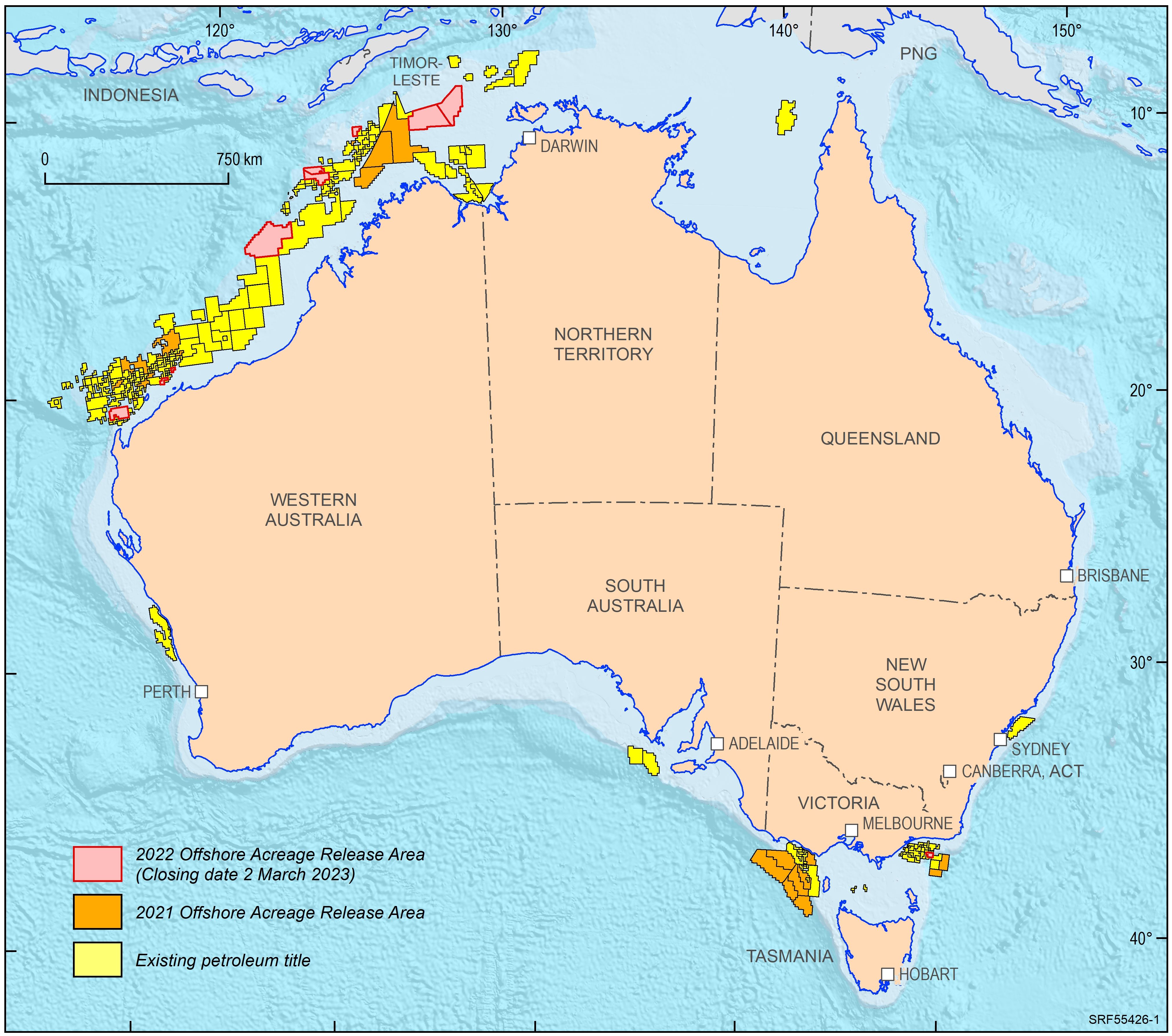
<div>In 2022, the Australian Government released ten offshore petroleum exploration areas. They are located in the Bonaparte Basin, Browse Basin, Northern Carnarvon Basin and Gippsland Basin. The areas highlight that producing provinces rather than data-poor regions are the preferred targets for exploration activities. In addition, the transition to low carbon energy resources, including opportunities for carbon capture and storage, has seen a diversification of energy companies’ portfolios. The Australian Government is supportive of the upstream energy industry, with natural gas seen as an important enabling energy resource commodity that supports the expansion of low emission technologies and related infrastructure. Most of the areas being offered for exploration in 2022 are likely to generate extra volumes of natural gas, both for domestic markets as well as securing feedstock for existing LNG export projects for the longer term. </div><div>Consistent with the approach of recent releases, only one period for work program bidding has been scheduled. The closing date for all bid submissions is 2 March 2023. </div><div>Geoscience Australia provides pre-competitive data and petroleum geological information in support of industry activities. Its petroleum geological studies aim to improve the understanding of the evolution of hydrocarbon-bearing basins at a regional scale and include a review of source rock and fluid occurrences, their geochemical characteristics, and petroleum systems modelling. Most recent examples include a sedimentological/stratigraphic study that investigates the depositional history of the southern Bonaparte Basin during the late Permian to Early Triassic evaluating the controls on reservoir facies development. A regional petroleum geological study of the Otway Basin, with a focus on the deeper water area and utilising newly industry acquired regional seismic data, provides new insights into the hydrocarbon prospectivity of this largely underexplored offshore part of the basin. Latest results of these studies were presented at this year’s APPEA conference. Large seismic and well data sets, submitted under the Offshore Petroleum and Greenhouse Gas Storage Act 2006 (OPGSSA) are made available through the National Offshore Petroleum Information Management System (NOPIMS). Additional data and petroleum related information can be accessed through Geoscience Australia’s data repository</div><div><br></div>
-
<div>Two new programs at Geoscience Australia are providing trusted, high-quality science to support decision making and the Australian resources industry. </div><div> </div><div>The Trusted Environmental and Geological Information program will provide baseline pre-competitive data in the Cooper, Adavale, north Bowen and Galilee basin regions. A repository of information is being developed in collaboration with CSIRO, including new geological and environmental assessments, to accelerate development in the sectors of petroleum, mineral, hydrogen and carbon capture and storage, while simultaneously providing opportunities to understand the potential hazards, risk and impacts of these resources being developed. </div><div> </div><div>The Data Driven Discoveries program is combining new and old data to better understand the under-explored Adavale Basin in central-western Queensland. The program will undertake chemical composition analyses to support the correlation of geological layers, collate and reprocess historical seismic data, acquire new seismic reflection data, and undertake stratigraphic research drilling to provide a more detailed understanding of basin architecture and the resource potential of the Adavale Basin. </div><div> </div><div>An overview of the Trusted Environmental and Geological Information and Data Driven Discoveries programs will be provided, including initial results and planned acquisition. This will show how these complementary programs will contribute to streamlined regulation and approval processes, the low emissions agenda, and responsible resource development in key basin regions across Australia.</div> This Abstract was submitted/presented to the 2022 Petroleum Exploration Society of Australia (PESA) QLD Symposium 9 September (https://pesa.com.au/events/pesa-qld-2022-symposium/)
-
<div>Geoscience Australia’s Onshore Basin Inventories program provides a whole-of-basin inventory of geology, energy systems, exploration status and data coverage of onshore Australian basins. Volume 1 of the inventory covers the McArthur, South Nicholson, Georgina, Wiso, Amadeus, Warburton, Cooper and Galilee basins and Volume 2 expands this list to include the Officer, Perth and onshore Canning basins. These reports provide a single point of reference and create a standardised national inventory of onshore basins. In addition to summarising the current state of knowledge within each basin, the onshore basin inventory identifies critical science questions and key exploration uncertainties that may help inform future work program planning and aid in decision making for both government and industry organisations. Under Geoscience Australia’s Exploring for the Future (EFTF) program, six new onshore basin inventory reports will be delivered. </div><div> </div><div>These reports will be supported by selected value-add products that aim to address identified data gaps and evolve regional understanding of basin evolution and prospectivity. Petroleum system modelling is being undertaken in selected basins to highlight the hydrocarbon potential in underexplored provinces, and seismic reprocessing and regional geochemical studies are underway to increase the impact of existing datasets. The inventories are supported by the ongoing development of the nationwide source rock and fluids atlas, accessed through Geoscience Australia’s Exploring for the Future Data Discovery Portal, which continues to improve the veracity of petroleum system modelling in Australian onshore basins.</div><div> </div><div>In summarising avenues for further work, the Onshore Basin Inventories program has provided scientific and strategic direction for pre-competitive data acquisition under the EFTF work program. Here, we provide an overview of the current status of the Onshore Basin Inventories, with emphasis on its utility in shaping EFTF data acquisition and analysis, as well as new gap-filling data acquisition</div> This Abstract was submitted/presented at the 2023 Australasian Exploration Geoscience Conference (AEGC) 13-18 March (https://2023.aegc.com.au/)
-
Geoscience Australia’s Exploring for the Future program provides precompetitive information to inform decision-making by government, community and industry on the sustainable development of Australia's mineral, energy and groundwater resources. By gathering, analysing and interpreting new and existing precompetitive geoscience data and knowledge, we are building a national picture of Australia’s geology and resource potential. This leads to a strong economy, resilient society and sustainable environment for the benefit of all Australians. This includes supporting Australia’s transition to net zero emissions, strong, sustainable resources and agriculture sectors, and economic opportunities and social benefits for Australia’s regional and remote communities. The Exploring for the Future program, which commenced in 2016, is an eight year, $225m investment by the Australian Government. This package contains data generated in the field as part of stratigraphic drilling operations in the Delamerian region of the western New South Wales during 2023 funded through the Exploring for the Future program. A range of geological, geophysical and geochemical data are included, as well as associated borehole information such as core photographs. The data can be viewed and downloaded via the Geoscience Australia Portal - https://portal.ga.gov.au/. The data that is available is from several databases which are associated to this record. <i>These data are published with the permission of the CEO, Geoscience Australia. </i>